East of the Sillon, past the Rochebonne point, Saint-Malo changes scale: Rothéneuf is a village within the town, with its coves, its lagoon and its carved cliff. This is the country of generous low tides and of shore foraging: the Saint-Malo quarter where the tide is lived closest to the sand, twenty minutes by bus from the ramparts.
The basin: a sea that leaves twice a day
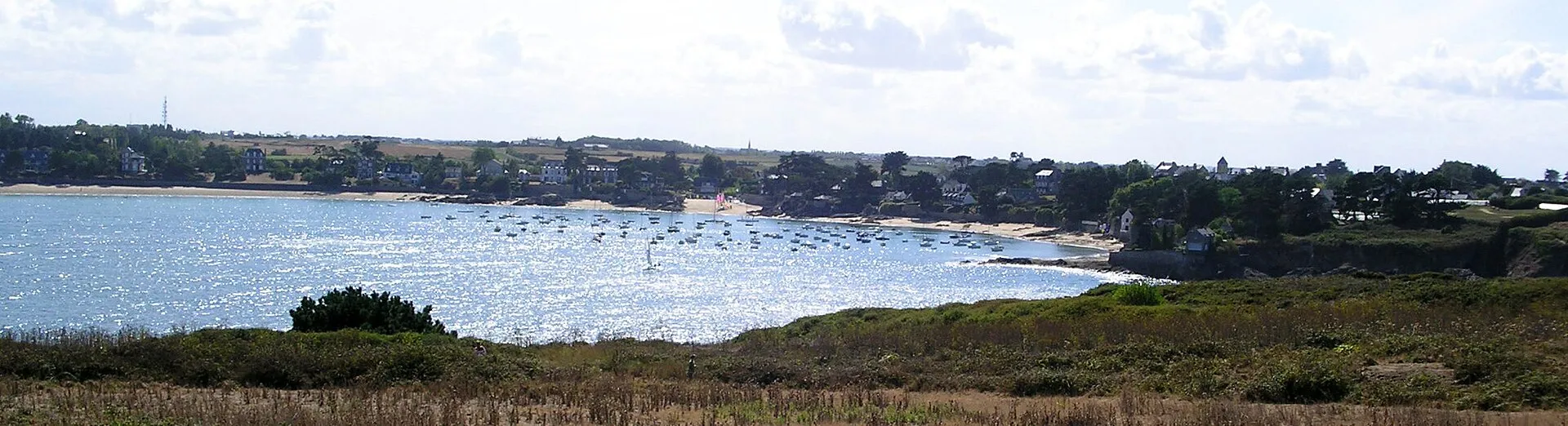
The Rothéneuf tidal basin is the local phenomenon: an almost closed lagoon, linked to the open sea by a narrow pass between the Pointe du Christ and La Guimorais. At high tide it is a sheltered sheet of water for swimming and paddleboarding; six hours later the sea has withdrawn almost entirely and the basin becomes an immense sand flat, striped with channels, where foragers rake for cockles and clams. Few places on this coast show the tidal range with such clarity: an entire landscape that appears and disappears.
The beauty has a serious counterpart: the rising tide refills the basin through the pass, fast and from behind. The channels swell before the sea even looks close, and the flat closes like a net. The rule here is the strictest on the coast: official SHOM times before you go down, the walk back begun at the turn, and no lingering at the far end of the basin.
The sculpted rocks: one man’s cliff
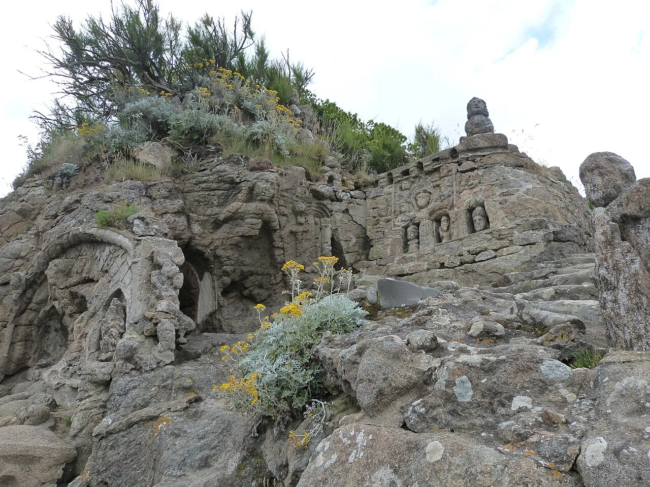
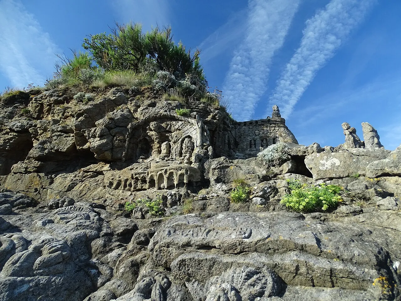
On the headland facing the open sea, a hermit spent thirteen years carving granite. Between 1894 and 1907, abbé Fouré, retired from the ministry after a stroke left him deaf, chiselled more than three hundred figures into the living cliff: sailors, corsairs, sea monsters, scenes from Saint-Malo legend. The result is one of Europe’s great outsider-art sites, beaten by the spray that slowly erodes it. The visit (paying site, hours to check locally) pairs ideally with high water, when the waves animate the sculptures’ base.
Beaches: from Le Val to La Guimorais
Rothéneuf lines up three registers of beach. The Val beach, family-friendly, framed by rocky points, closest to the village. The Havre beach, on the lagoon: calm, warm water at high tide, an infinite playground at low tide. And beyond the pass, La Guimorais and its great wild beaches between dunes and headlands: the beginning of the Saint-Coulomb coast, where the spring-tide foreshore uncovers some of the region’s finest foraging grounds. All appear in the list below and on the map, with their access notes.
⚠ Places marked “low tide only” can only be reached at low tide: check the official SHOM tide times before crossing. Official tide times (SHOM) ↗
Rothéneuf
Besnard island and Chevrets beach
Rothéneuf
North of the Rothéneuf inlet, the wild sweep of Chevrets beach backs onto dunes between Besnard island and the Pointe du Meinga. The island is reached along a sand spit, and the path around it strings together coves and viewpoints over the open sea. An ideal loop at low water, when the sand carries you everywhere. The inlet itself all but empties at low tide: a landscape of sand and channels that changes by the hour, before the flood fills it again. Few facilities and a lot of space: the counterpoint to the urban beaches of the Sillon. Keep an eye on the rising tide if you wander out across the banks.
Carved rocks of Rothéneuf
Rothéneuf
Father Adolphe Julien Fouré, who withdrew to Rothéneuf after a stroke left him deaf and nearly mute, spent a quarter of a century (c. 1894-1919) carving several hundred figures straight into the granite of the shore: the imaginary saga of the Rothéneuf clan, a lineage of corsairs and sea monsters rising out of the rock to face the open sea. The path overhanging the water is best taken slowly, hunting for faces in the stone; spray and frost erase the work a little more each year, which makes seeing it all the more precious. Private site with an admission charge. The raking light of late afternoon suits the visit well.
Between the Meinga headland and Les Chevrets, the Guimorais foreshore borders the Rothéneuf tidal basin, which empties almost completely at low water: firm sand, pools, shellfish beds. It is one of the busiest shore-foraging grounds on spring tides, and a fine walk in any season once the sea has withdrawn, in a landscape that changes hour by hour. But the basin refills through a narrow channel and the sea comes back far faster than it left: check the official SHOM tide times before going down onto the flats, and start back as soon as the tide turns, without waiting to see the water arrive.
On the far side of the Pointe de la Varde, Le Val opens the sequence of Rothéneuf beaches: wilder, backed by dunes and facing due north. When the swell gets in, the waves here are among the cleanest in the area, and at high water the beach makes a fine vantage point for watching them roll in. At low tide the sand spreads wide and almost reaches the Rothéneuf inlet: the hour for long walks and beach games, as the foreshore uncovers stretch after stretch of fresh sand. Fewer facilities than in town: you come here for space, for light and for the sound of the open sea.
Limoëlou manor (Jacques Cartier museum)
Rothéneuf
The only surviving home of Jacques Cartier: the discoverer of Canada bought this Rothéneuf farm on returning from his voyages and enlarged it into a manor, where he lived until his death in 1557. Restored and furnished as in the 16th century, the house is visited in the company of a guide, among maps, sailing routes and the daily life of a Saint-Malo captain between two Atlantic crossings, a tangible way of grasping what setting out for the unknown once meant. The visit is fairly short and pairs very well with the neighbouring carved rocks to make a half-day in Rothéneuf.
Guided tours; days and times vary by season.
Pointe de la Varde
Rothéneuf
This heathland promontory between the Minihic and Le Val closes the bay to the east, some thirty metres above the water. A former military site (blockhouses of the Atlantic Wall remain), it is now a protected natural area crossed by the customs officers' path (GR 34). The view sweeps full circle: the Saint-Malo roadstead and the Sillon on one side, the coast towards Rothéneuf and Cancale on the other. At spring tides, foam bursts over the reefs at the foot of the point: its height makes it a safe post for watching heavy weather from afar. Even so, keep to the paths, well back from the cliff edge.
Résidence Reine Marinesea view
Rothéneuf · €€€
A four-star residence of 66 apartments set on Minihic beach near the Pointe de la Varde: a panorama over the bay of Saint-Malo, an indoor pool with a sea view, spa and hammam. This is the spring tide in its peaceful version, away from the Sillon crowds. The GR 34 coastal path runs at the foot of the residence and leads to the headlands and beaches of Rothéneuf.
The Rothéneuf inlet empties and refills through a narrow channel: on the flood, the current reaches the speed of a river in spate and the sandbanks at the back of the cove become cut off very quickly. Walkers heading for Besnard island or crossing the inlet at low tide must turn back at slack water. The rising tide cuts the low points first, behind you, where nobody is looking. Check the time of low water before stepping onto the sand and keep a generous margin. Swimming in the channel at mid-tide is unwise even for strong swimmers: whichever way the current runs, it is stronger than you are.
An almost closed lagoon, linked to the sea by a narrow pass: at high tide, a peaceful sheet of water; at low tide, an immense sand flat from which the sea withdraws almost entirely. It is eastern Saint-Malo's great foraging ground, and a place the rising tide refills fast and from behind: you leave at the turn.
What are the sculpted rocks of Rothéneuf?
An entire cliff carved between 1894 and 1907 by abbé Fouré, a local hermit: more than three hundred granite figures (sailors, monsters, Saint-Malo legends) cut into the living rock facing the sea. A monumental work of outsider art, unique in Brittany, on its headland above the waves; paying site, opening hours to check locally.
Which beaches should you pick in Rothéneuf?
The Val beach, family-friendly and framed by rocks, on the town side; the Havre beach on the lagoon, ideal with young children at high tide; and eastwards the great wild beach of La Guimorais, between dunes and headlands, which meets the basin's sands at low water. Each entry below says what the tide changes there.