Saint-Malo tells its story from the wall walk. Two kilometres of ramparts enclose a town rebuilt stone by stone after 1944, and the circuit, free and open day and night, remains the finest introduction: on one side the shipowners’ austere granite mansions, on the other the bay, with the Grand Bé and Fort National sitting on water or on sand depending on the hour. Staying Intra-Muros lets you walk it at first light, before the crowds.
Because here, even the heritage keeps tidal hours. Fort National, the Grand Bé and Chateaubriand’s tomb can only be reached on foot, when the sea consents to uncover their causeways. The places to stay facing the islands put the crossing window right outside your room. At high water on a big coefficient, the ramparts themselves become the front balcony of the show.
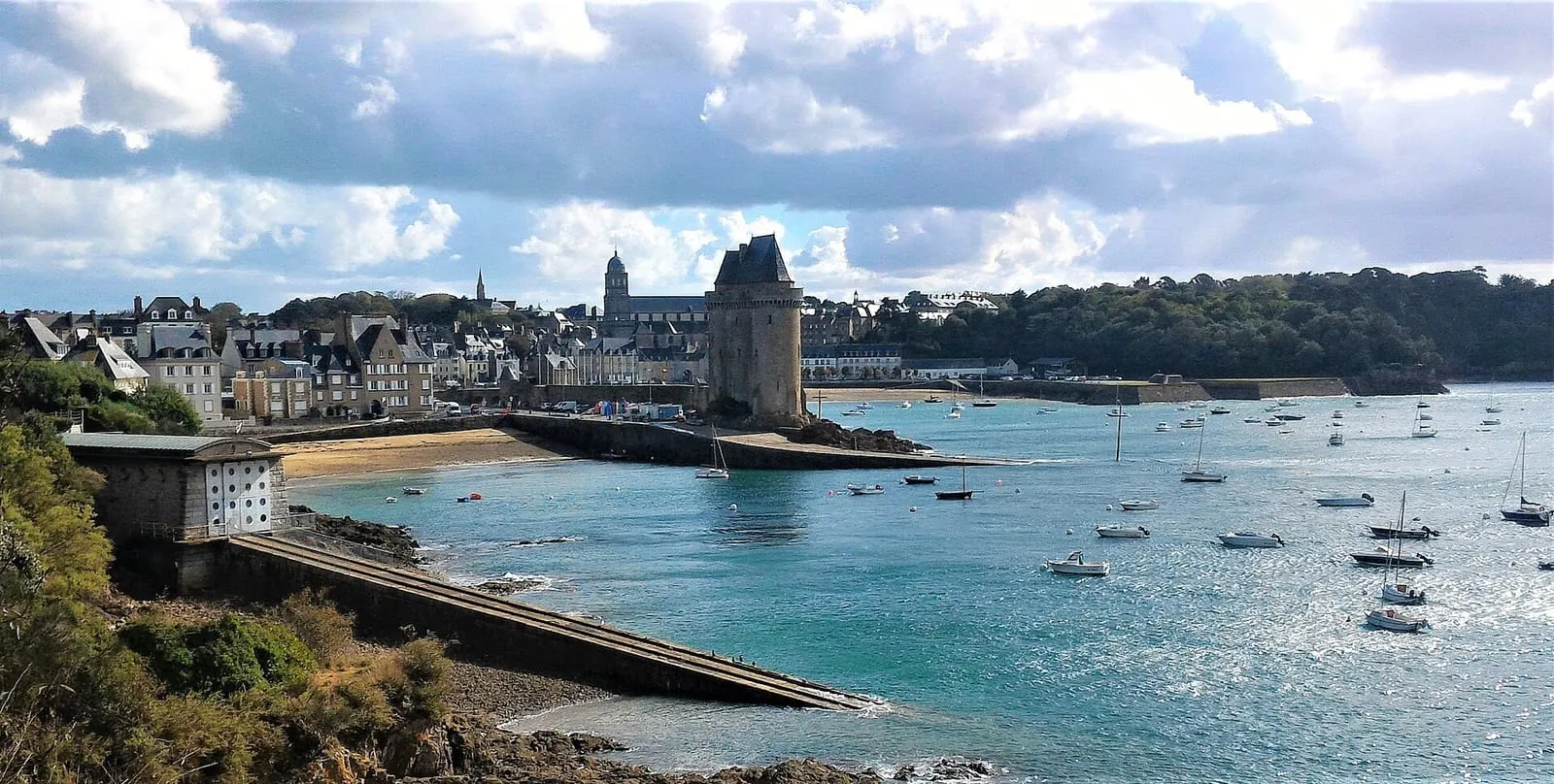
Beyond the walls, Saint-Servan keeps the Solidor tower and the remains of the city of Alet, the town’s first site; the corniche gives the finest view over the roadstead. Inland and along the Rance, the malouinières (La Chipaudière, Le Bos, Le Puits Sauvage) tell of the shipowners’ fortunes in Saint-Malo’s golden century, fifteen minutes from the walled city.
A town destroyed, rebuilt stone by stone
What you admire from the wall walk is a little-known tour de force: in August 1944, the fighting of the Liberation destroyed four-fifths of the walled town. Only the ramparts, a handful of façades and a field of ruins were left standing. Rather than rebuild modern, Saint-Malo chose fidelity: under architect Louis Arretche, the city was raised again in granite to its pre-war plan and volumes. The same alignments, the same slate roofs, the same tall shipowners’ chimneys. The project ran for more than twenty years, up to the spire of Saint-Vincent cathedral, set back in place in the early 1970s.
Hence a town with a delicious paradox: almost everything in it is less than a century old, and none of it looks it. A few authentic survivors reward the curious: the so-called Duchesse Anne house, stretches of street around the cathedral. And the ramparts themselves really are the ones Chateaubriand grew up on.
The heritage the tide uncovers
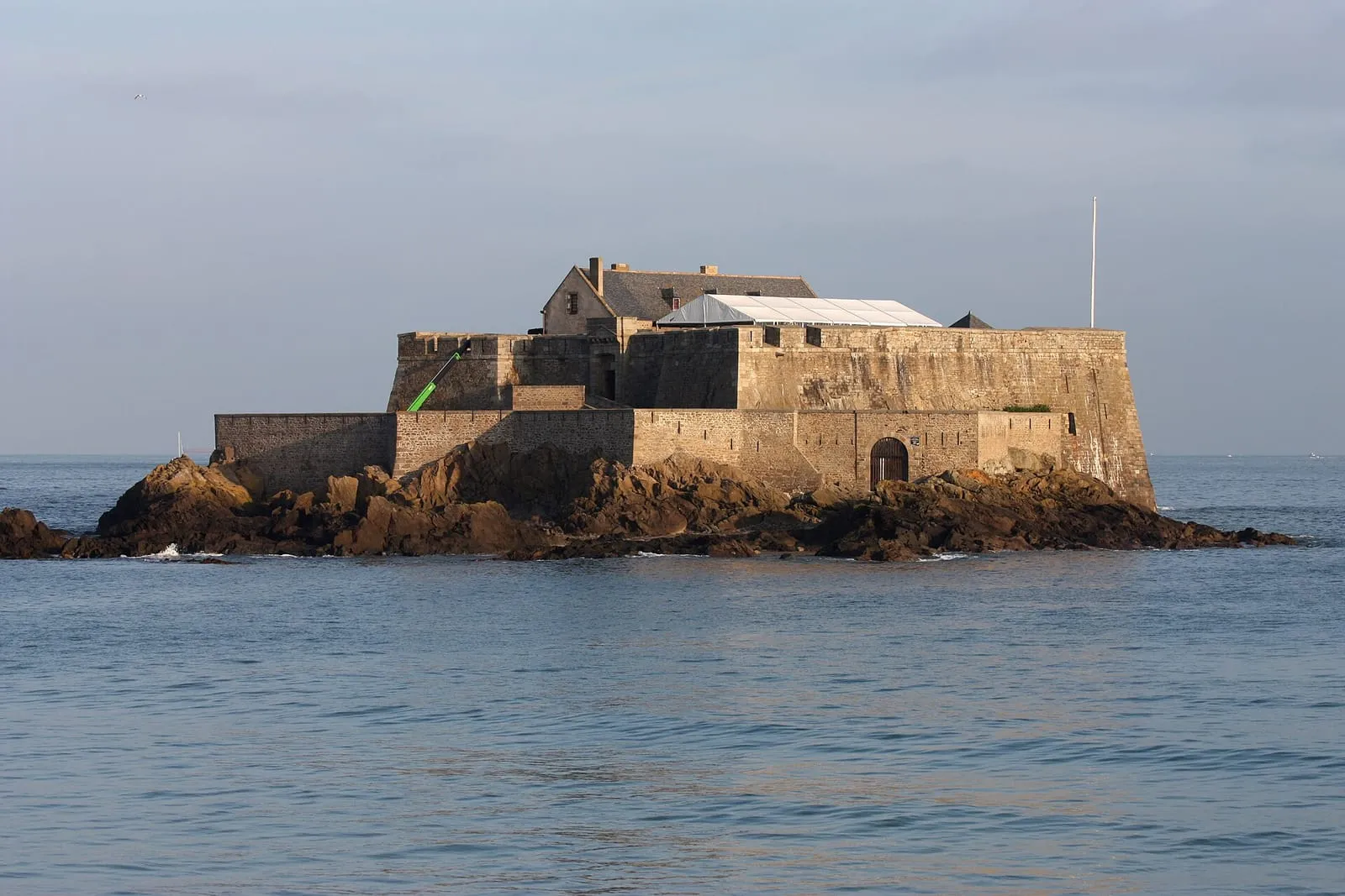
The roadstead of Saint-Malo is an open-air museum of military architecture, and the tide is its keeper. Around the city, four forts designed under Vauban by local engineer Garangeau crossed their fire to close the bay: Fort National and the Petit Bé, joined to the beaches by low water; La Conchée, set offshore on its wave-battered rock; and the fort on Harbour island, in the middle of the channel to Dinard. Two can be visited to the tide’s timetable, the other two are admired from the ramparts or the tour boats. At low tide the foreshore uncovers their foundations, invisible the rest of the time.
At the mouth of the Rance, the Solidor tower has stood guard since the 14th century opposite the môle des Noires, and the contrast sums the town up: on one side heritage that defies the sea, on the other the works that tame it. On big-coefficient days, the wave show over the breakwater is best watched from the Alet corniche, exactly where the city was born.
A heritage day, set to the tide
Saint-Malo’s heritage is better visited with a tide table than with a street plan. At high water, take the high ground: the circuit of the ramparts, the castle esplanade, the Alet corniche. The forts are islands, the roadstead is full, the stage is complete. On the ebb, drift inland: Saint-Vincent cathedral, the corsair’s mansion or the rebuilt lanes (the history museum in the castle has been closed since 2019), the heritage that keeps no tidal hours. At low water, the crossings: Fort National from the Éventail, the Grand Bé and Chateaubriand’s tomb from Bon-Secours, with one eye on the turn. On the flood, finally, a quarter of an hour’s drive to a malouinière or the Solidor tower closes the loop while the sea takes back the bay.
A single high water and a single low water are enough for this score: that is the point of timing the visit to a spring tide day, when the contrast between the two towns, the island one and the mainland one, is at its strongest.
All these places are listed below by area, and gathered on the interactive map together with the spring-tide viewpoints. For the sites marked “reachable at low tide”, one reflex only: the official SHOM tide times before you cross.
Built in 1725 for Auguste Magon de la Lande, shipowner, corsair and director of the French East India Company, this mansion is one of the few great shipowners' houses of the walled town to have come through the fire of 1944. The guided tour leads from the panelled salons to the vaulted cellars through which cargoes once passed, then up to the rooftops from which the return of the ships was watched: the whole machinery of a Saint-Malo merchant house, from hold to lookout. A distillation of the city's fortune in the privateering era. Guided tours; check days and times.
In August 1944 the battles of the Liberation destroyed nearly 80% of the walled town; it was rebuilt identically, in granite. The ramparts themselves are original, raised between the 12th and 18th centuries and extended by the engineer Garangeau to Vauban's designs. The full wall-walk runs 1.7 km, free of access, punctuated by the statues of the corsairs Duguay-Trouin and Surcouf, the latter pointing his finger at England. Walk the circuit twice if you can: at high tide the sea comes to beat against the foot of the walls, while at low tide uncovered beaches and rocks entirely recompose the landscape below.
The castle guarding the entrance to the old town was enlarged by Duchess Anne of Brittany against the wishes of the Malouins; the tower she imposed on them in 1498 still bears her answer to their protests: “Quic-en-Groigne” (let whoever grumbles grumble, so shall it be). The fortress now houses the town hall, and the history museum in the great keep is closed pending the future maritime museum, so check the project's status before visiting. What remains freely open is the walk around the moats and the view from Éventail beach, the best place from which to read the castle, set between town and sea.
At the highest point of the rock, the cathedral combines a Romanesque nave with a Gothic choir. Jacques Cartier received the bishop's blessing here before sailing for Canada in 1535; a slab now marks his grave, identified in 1949. The spire, brought down by the bombardments of 1944, was only restored in 1972. Its silhouette still guides sailors on their approach, a fixed mark above a roadstead the tide redraws endlessly. Inside, the contemporary stained glass by Jean Le Moal and Max Ingrand, installed during the reconstruction, floods the nave with colour. It makes a cool, quiet refuge after the wall-walk.
The sentinel of the roadstead: planted on its reef west of Cézembre, the lighthouse guides shipping into Saint-Malo's main channel. Dynamited by the German army in 1944, it was rebuilt identically in 1950 and later automated. It cannot be visited, yet it punctuates every Saint-Malo horizon, and the excursion boats for Dinard, Cézembre or Cap Fréhel pass right at its foot, the best way to see it close up. The tide transforms it: at a big low tide its rocky base uncovers widely and the tower seems to grow taller on its own granite island, before the flood gives it back to the sea.
Harbour island and its fort
Roadstead & offshore islands
In the middle of the roadstead between Saint-Malo and Dinard, Harbour island carries one of the forts designed under Vauban by the local engineer Garangeau, together with La Conchée, Fort National and the Petit Bé: an artillery lock whose crossfire was meant to close the bay to enemy squadrons. The fort is private and cannot be visited, but it rewards a long look from the bay's tour boats, the Moulinet headland or the wall-walk of the ramparts. The tide changes the whole picture: at a spring low tide the island doubles in size and uncovers its rocky base, before the flood shrinks it back to a lone fortified silhouette.
La Conchée fort
Roadstead & offshore islands
The military masterpiece of the roadstead: a fort wedded entirely to its rock, four kilometres offshore, which Vauban himself counted among his most audacious works. Bombarded as early as 1693 by the English fleet (which it helped repel) and strafed in 1944, it has been under stone-by-stone restoration by an association since the 1980s. It opens only very occasionally, so most visitors admire it from the excursion boats, the Pointe de la Varde or the Sillon, set on the horizon like a ship of stone. Its silhouette stands out all the better when low tide uncovers the reefs around it.
Saint-Servan
Alet headland
Saint-Servan
This is where Saint-Malo began: the Alet peninsula carried the Gallo-Roman city and the first bishopric, before people and power moved to the neighbouring rock, easier to defend. What remains: the ruins of Saint-Pierre cathedral, stretches of rampart and the 18th-century fort honeycombed with galleries by the German army. The 1939-45 memorial can be visited there. The path circling the peninsula beneath the trees gives the best view of the harbour entrance, the islets and Dinard; at low tide, uncovered rocks and strands sketch a whole landscape around the headland that high water erases within a few hours.
South of Saint-Servan, a great public park overlooking the Rance: meadows, cedars and riding avenues surround a 19th-century château, heir to an older malouinière. This is where the Malouins take their Sunday stroll, before one of the finest views to be had over the estuary, the dam and Dinard. It is also a surprising vantage point for watching the tide travel back up the Rance: on the flood, the current turns before your eyes and the whole of the estuary slowly fills like a lake. Access to the park is free; the château itself opens only occasionally.
Above the hamlet of Quelmer and the La Passagère slipway stands an early-18th-century malouinière attributed to Garangeau, resolutely turned towards the Rance: the shipowners reached their houses by boat, riding the tide, faster than any horse and carriage could manage. The estuary was the highway of the day. The granite house is ordered between courtyard and garden, extended by a hornbeam walk and a view over the estuary which, once contemplated, explains the choice of site by itself. Private property open for guided tours in summer. Check days and times before coming.
Three joined towers from the 14th century, built by Duke John IV of Brittany to hold the Rance estuary and to keep an eye on a then-rebellious Saint-Malo. Long home to the Cape Horners' museum, the tower is being redeveloped, so check it is open before visiting. The setting itself rewards a visit at any hour: the cobbled slipway, the fishermen's houses of Saint-Servan, the light on the estuary. The tide writes two different scenes here: at low water the Solidor cove empties and hulls lie on the mud waiting for the flood; at high water the sea returns to the foot of the towers.
Ten minutes from the centre, Saint-Malo's aquarium has made a speciality of staging: a 360° ring where the sharks circle, a touch pool where children reach out a hand, and the “Nautibus”, a small submarine that genuinely dives into a populated tank. A few hundred species follow one another here, from cold seas to the tropics: a way of carrying on the exploration of the shore by other means. It is the safe bet for rainy days and for high-tide hours, when the foreshore has vanished beneath the sea and the children are getting restless: spend high water here, then return to the uncovered rocks.
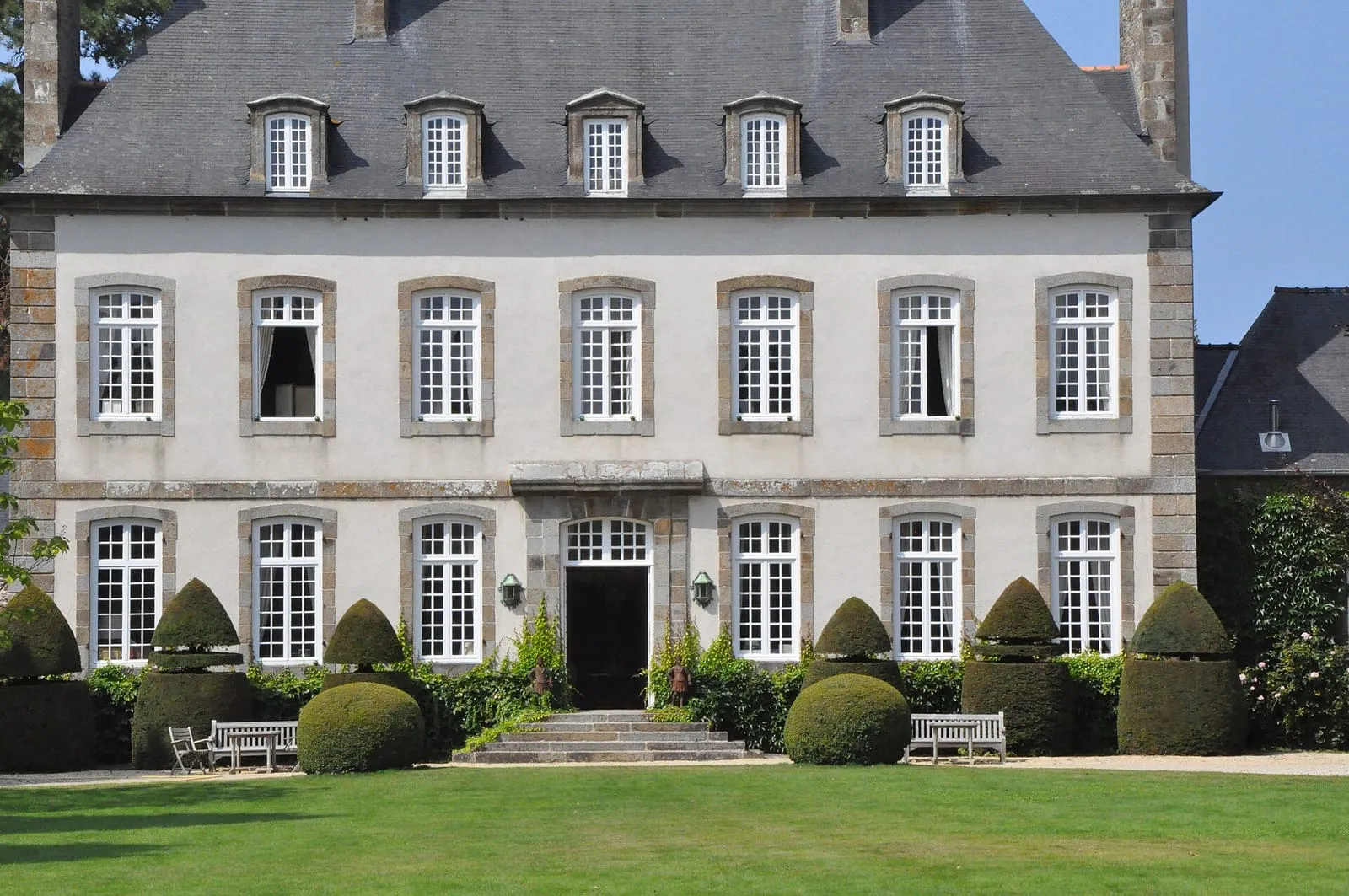
The most famous of the malouinières, the country houses Saint-Malo's shipowners built for themselves once the fortunes of privateering and trade overflowed the ramparts. Raised around 1710 for François-Auguste Magon de la Lande, to plans attributed to Garangeau, Vauban's architect, it aligns its classical façade between courtyard and formal French garden, with the granite sobriety that marks the shipowners' quiet wealth. Three centuries on, the Magon family still lives here. Private property: the exteriors can be seen, with occasional open days, best checked before you go.
Rothéneuf
Carved rocks of Rothéneuf
Rothéneuf
Father Adolphe Julien Fouré, who withdrew to Rothéneuf after a stroke left him deaf and nearly mute, spent a quarter of a century (c. 1894-1919) carving several hundred figures straight into the granite of the shore: the imaginary saga of the Rothéneuf clan, a lineage of corsairs and sea monsters rising out of the rock to face the open sea. The path overhanging the water is best taken slowly, hunting for faces in the stone; spray and frost erase the work a little more each year, which makes seeing it all the more precious. Private site with an admission charge. The raking light of late afternoon suits the visit well.
The only surviving home of Jacques Cartier: the discoverer of Canada bought this Rothéneuf farm on returning from his voyages and enlarged it into a manor, where he lived until his death in 1557. Restored and furnished as in the 16th century, the house is visited in the company of a guide, among maps, sailing routes and the daily life of a Saint-Malo captain between two Atlantic crossings, a tangible way of grasping what setting out for the unknown once meant. The visit is fairly short and pairs very well with the neighbouring carved rocks to make a half-day in Rothéneuf.
In Saint-Coulomb, at the heart of the Clos-Poulet, one of the most complete malouinières there is: a main house of 1715, a chapel, a dovecote and walled gardens compose the exact picture of the shipowners' countryside, a league from their counting houses. Far enough from the port to breathe, close enough to keep an eye on business. In summer the guided tour recounts wars and sea fortunes among the furniture and keepsakes of the families who followed one another here, and you leave with a clear sense of how these merchant dynasties lived. Check visiting days and times according to the season.
The only malouinière built on the left bank of the Rance, at Pleurtuit: raised in the 18th century for a shipowner who added a shipyard and a slipway on the estuary, proof that these country houses stayed turned towards the sea and its business. Its terraced gardens, listed as a “remarkable garden”, step down to the water, mixing French parterres with a scented garden; from the terraces you can follow the tide's comings and goings on the estuary. The place sums up what the maritime Rance was: Saint-Malo's second seafront, lined with residences and slipways. Open to visitors in season; check the hours.
The maritime Rance once counted more than a dozen tide mills: a dyke closes off a cove, the sea fills it on the flood, and the water released on the ebb turns the wheel. It is the same principle as the tidal power station, five centuries early. The Prat mill, attested from the 15th century, was rescued and restored to working order by an association; in summer, visits and demonstrations show the machinery at work, to a timetable set by the tide itself. All around, the adjoining cove, its salt meadows and its path sum up the Rance as it was before the dam. Come on a rising or falling tide to watch the water move.
Visits and demonstrations in summer; check the dates.
Saint-Samson's cathedral, a Gothic vessel of granite at the gates of the marsh, recalls that Dol was one of Brittany's great religious seats. It was a port too, in the days when the sea reached the foot of the town, before it withdrew from the marshland. Its north front, austere as a fortress, once looked towards the shore; walk right around it to take the measure of a maritime past that has become a landscape of land won from the sea. Around it, the old town keeps its medieval arcaded houses, made for unhurried wandering. An ideal stop to pair with nearby Mont-Dol on the road to Mont-Saint-Michel.
Do you have to pay to walk the ramparts of Saint-Malo?
No: the wall walk is free and open at all times. Allow a good hour for the full circuit, two kilometres from the Saint-Vincent gate to the Hollande bastion, and if you can, pick a high tide on a big coefficient: from up there the wave show is at its safest and most spectacular.
Can you visit Fort National?
Yes, in season and at low tide only: the fort is reached on foot from Éventail beach when the sea uncovers the causeway, flag flying on opening days. The guided tour tells the story of Vauban and the corsairs. Mind the return leg: the rising tide cuts the rock off. Check the SHOM tide times.
What is a malouinière?
The country house of Saint-Malo's shipowners, grown rich on privateering and long-haul trade, built in the 17th and 18th centuries across the Clos-Poulet hinterland and along the Rance. Austere outside, refined within, a few open to visitors in summer, La Chipaudière and Le Bos in particular.
Can you visit the forts of the roadstead?
Fort National opens to visitors at low tide in season, and the Petit Bé fort can also be reached over the causeway at big low tides. La Conchée and the Harbour island fort, by contrast, cannot be visited: admire them from the ramparts, the Moulinet headland or the bay's tour boats. Together they formed the ring of artillery designed in Vauban's day to close the bay.
Are the ramparts and the old town original?
The ramparts, essentially yes: they survived the bombardments of 1944. The walled town itself was four-fifths destroyed at the Liberation, then rebuilt in granite in the spirit of the old: a project of more than twenty years, completed by the cathedral spire in the early 1970s. It is that faithful reconstruction that makes the whole so convincing.


.jpg)

,_quartier_de_Saint-Servan,_Saint-Malo.jpg)