In Saint-Malo, a beach is never the same two hours running. With one of the largest tidal ranges in Europe (up to 13 metres between low and high water), the sand appears and disappears with the tide: the interactive map shows every beach and every low-tide crossing, and this page gathers them all, sorted by area.
On the town side, the great Sillon beach unrolls its three kilometres from the Saint-Thomas gate to Rochebonne. At the foot of the ramparts, Bon-Secours and its seawater pool face the sun setting behind the Grand Bé. The causeway dries out at low tide, and staying opposite the islands lets you watch for the crossing window from your room. On the other side of the walled city, the Môle beach shelters from the east wind, the Éventail opens the way to Fort National, and Saint-Servan hides Bas-Sablons, protected by the Solidor slipway. Eastwards, Rochebonne, the Minihic and Le Pont string together the family coves of Paramé out to Rothéneuf, where the foreshore becomes foraging ground on the big tides.
The Sillon, the monument among beaches
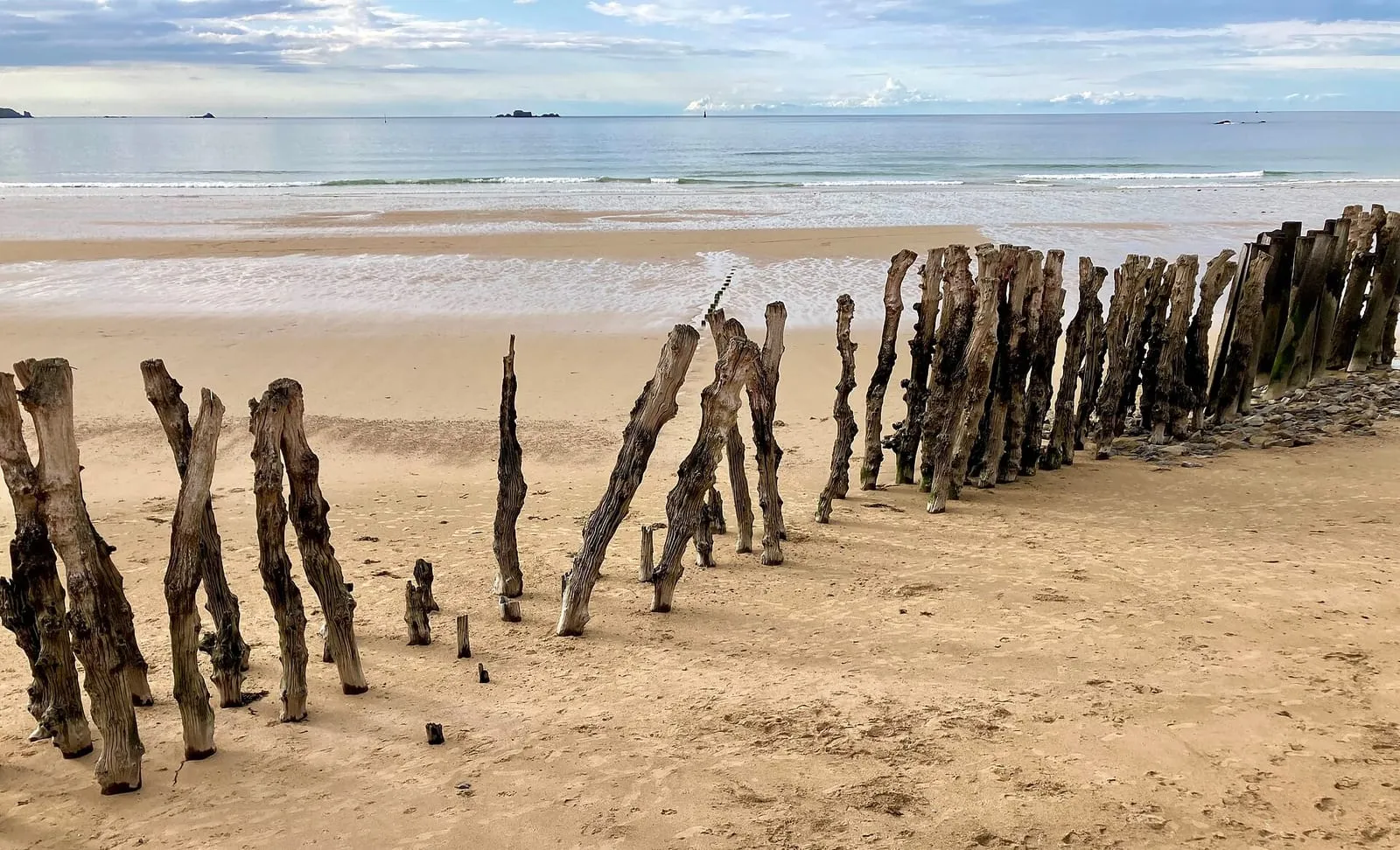
Three unbroken kilometres, backed by the sea wall that protects the town’s isthmus: the Sillon is as much a monument as a beach, regularly ranked among the finest in France. Its signature is the oak breakwaters planted in close ranks in front of the wall: hundreds of whole trunks, renewed since the 19th century, which break the waves’ energy before the wall and draw a perspective like no other at low tide.
The beach lives two lives. At low water, a desert of firm sand where you walk out past the breakwaters, from the Naye to Rochebonne, crossing sailing-school hand-carts, joggers and low-water anglers. At high water on a big coefficient, no beach at all: the sea pounds the wall and the seafront hotels find themselves in the front row. And if swell joins in, the sea leaps and the promenade itself crosses over to the show’s side, to be watched from a safe distance, behind shelter.
The Bon-Secours pool, a user’s guide
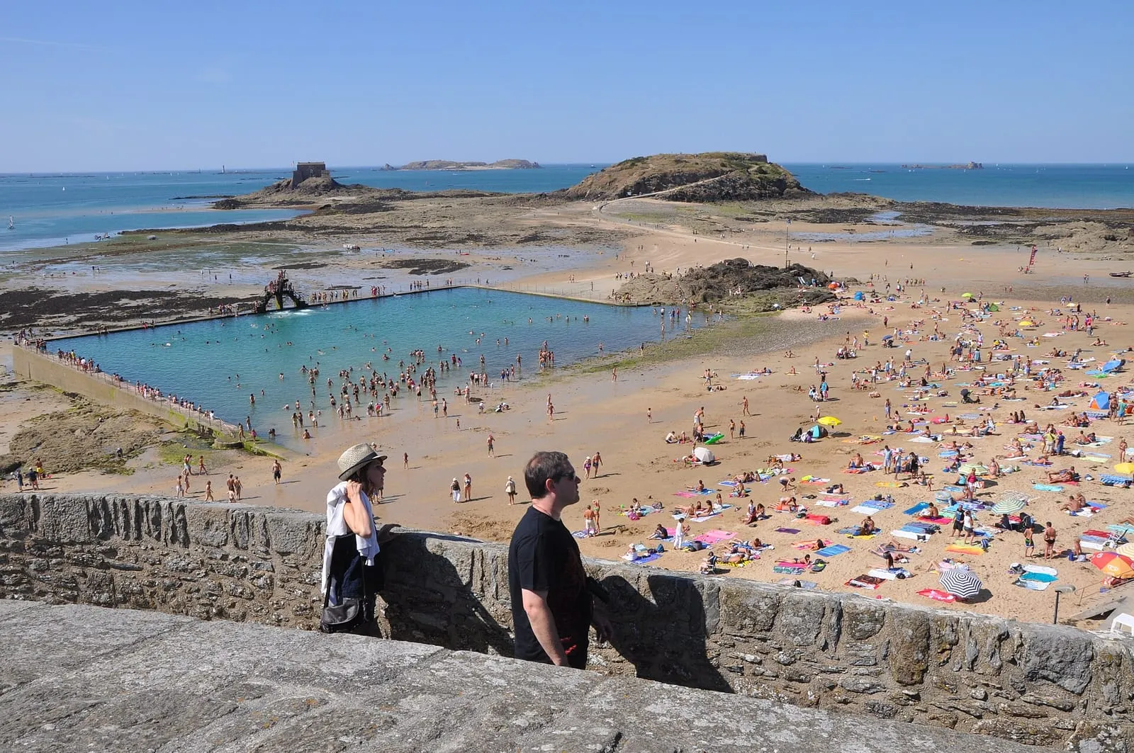
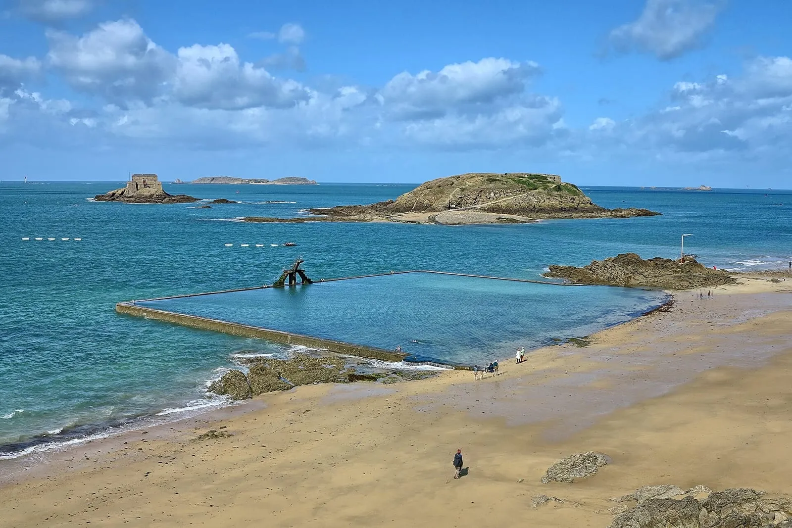
This granite basin, built in the 1930s at the foot of the ramparts, is refilled and renewed by every high tide. When the sea retreats several hundred metres, it remains the only deep-water swim in town, with its three-tier diving board, the rite of passage of Saint-Malo summers. Access is free; the bottom, slippery with seaweed near the steps, deserves a little care, and keep an eye on children: the pool is not permanently supervised.
Which beach for what
To swim without watching the clock: Bon-Secours and its pool. With children: Bas-Sablons, sheltered and gently shelving, or the Minihic and Le Pont coves in Paramé, calmer than the great Sillon. For walking: the Sillon at low tide, of course, out to the Rochebonne point and beyond. Sheltered from the east wind: the Môle beach, tucked against the ramparts. For the sunset: Bon-Secours, facing the two Bés. To be alone: Le Val and La Guimorais towards Rothéneuf, or La Touesse towards Saint-Coulomb. The entries below give the access and what the tide changes there.
Swimming by the tide
In Saint-Malo you pick your swimming hour from the tide table as much as from the weather forecast. The best moment is often the rising tide: the water comes back in over sun-warmed sand and gains two or three degrees on the way. At low tide the sea is far out, but the warm pools between the breakwaters delight small children, and the Bon-Secours pool takes over for swimmers. At high water on a big coefficient the beaches shrink to a ribbon: keep your belongings close, and stay away from the sea walls and slipways as soon as the swell starts sending waves over them. That show is watched from a safe distance, behind shelter.
One reflex before any outing: the places marked “reachable at low tide” below are cut off as the tide rises, and the sea here comes back faster than you can walk. Always check the official SHOM tide times before crossing to an island or heading far out on the foreshore, and the spring tide calendar will tell you on which days the foreshore gives its very best.
⚠ Places marked “low tide only” can only be reached at low tide: check the official SHOM tide times before crossing. Official tide times (SHOM) ↗
The Sillon
Sillon main beach
The Sillon
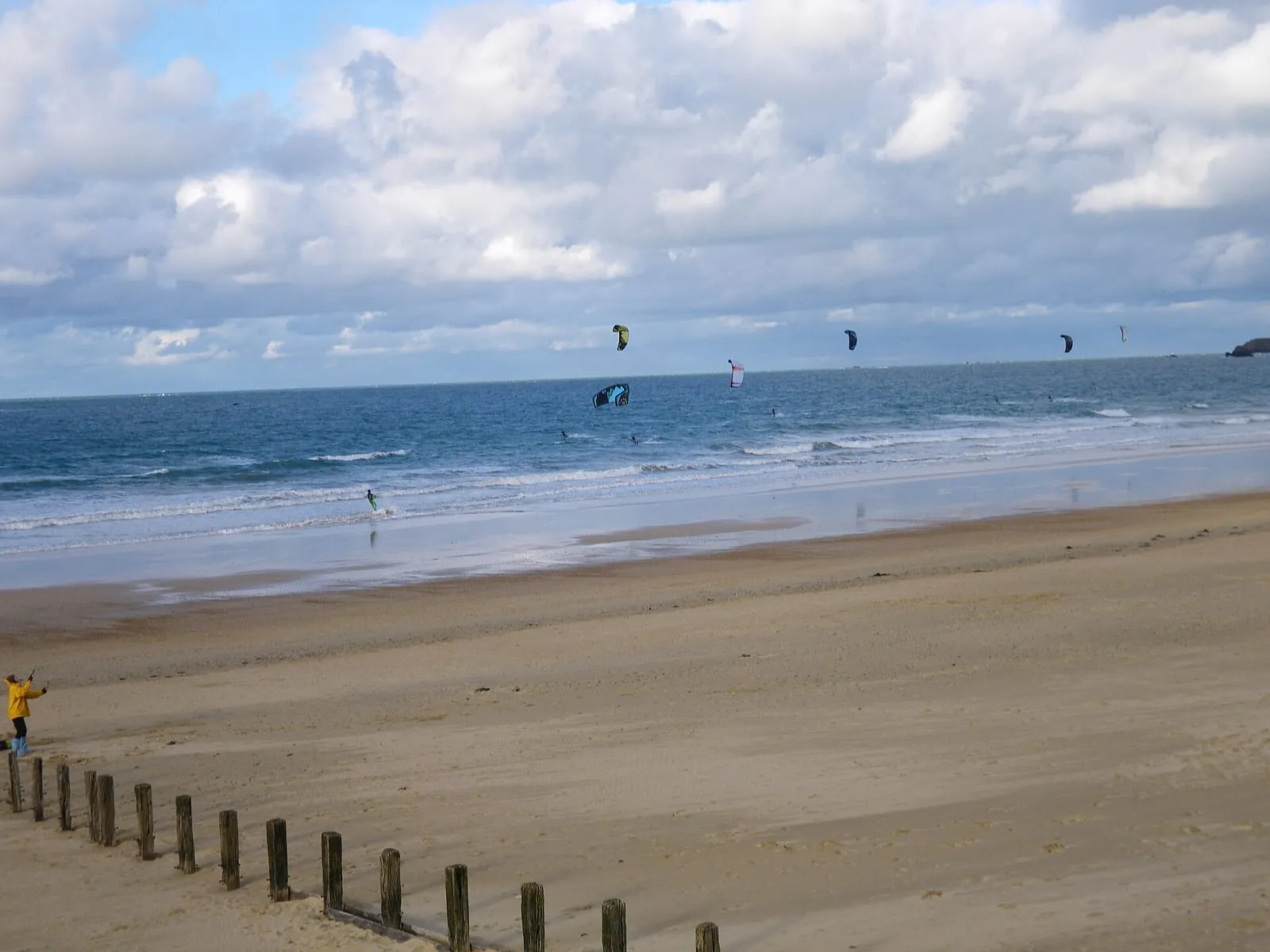
The three-kilometre urban beach running along the sea wall, regularly ranked among the finest in France, and the place where Saint-Malo's tidal range puts on its best show. At a big-coefficient high tide it vanishes altogether and the sea comes to pound the wall; at low tide it stretches out for hundreds of metres, punctuated by the lines of oak breakwater posts. Lifeguarded in summer at several stations; the immense foreshore lends itself to walking, kite-flying and endless end-of-day swims. On the biggest tides, keep well back from the wall when the waves start coming over it.
The locals' beach, below the western ramparts, famous for its 1930s seawater pool: a stone basin refilled by every tide, overlooked by its emblematic diving board. You can swim whatever the hour of the tide, even when the sea has withdrawn far out. It is also the starting point of the low-tide crossing to the Grand Bé: check the tide times before crossing, and come back before the flood covers the causeway. The sunsets from the sand, facing the islets, are among the most celebrated in town: an evening high tide makes the perfect setting for them.
Saint-Malo's answer to low tide: when the sea retreats several hundred metres, this 1930s granite basin keeps its water, refilled and renewed at every high tide. Its three-tier diving board has become one of the town's emblems, often photographed at sunset. You can swim at any state of the tide, which is precisely what it was built for: while the sand lies bare as far as the eye can see, the swimming carries on here. But there is no lifeguard off season, and the bottom stays slippery with seaweed near the steps: take care with children.
At the foot of the castle, this is the beach nearest the ramparts on the Sillon side, facing the rock of Fort National. Everything here reads by the hour of the tide: at low water you set off dry-shod towards the fort as the foreshore opens wide; at high tide only a ribbon of sand remains below the walls. Busy in summer for its location, it is above all a front-row seat for the spring tides: at high water the waves come to pound the rock armour beneath the castle. If you cross to the fort, check the tide times and come back before the flood closes the passage.
Fort National
Intra-Muros
On its rock facing Éventail beach, this fort designed by Vauban in 1689 and built by Garangeau in Chausey granite guarded the roadstead together with the Petit Bé and La Conchée. You walk out to it dry-shod at low tide; the flag flying means the guided tour is open, in season. From the rampart walk, an unbeatable view over the Sillon and the city walls: depending on the hour of the tide, sea on every side or an immense desert of sand. At the biggest coefficients the sea uncovers the crossing generously, then closes it again in under an hour: check the tide times before walking out, and don't wait for the first pools to head back.
Visits at low tide, roughly Easter to late September. The flag is flown when the fort is open.
The islet where Chateaubriand chose to be buried so he could “converse only with the sea”: his grave, a nameless slab topped with a cross, has faced the open water since 1848. You reach it dry-shod from Bon-Secours beach along a causeway the sea uncovers around mid-tide: a fine moment to climb up and catch the evening light over the bay. Walking round the islet gives the finest close-up view of the ramparts. But the sea cuts the Grand Bé off for several hours at every tide: check the official tide times before crossing and head back as soon as the flood reaches the causeway. Rescuing stranded walkers is a local classic.
A small beach tucked between the Holland bastion and the Môle des Noires, the most sheltered at the foot of the ramparts. Fine sand and little swell in westerly weather thanks to the pier: this is the fallback on windy days, when the Sillon is unusable. The tide redraws the place entirely: at low water the beach merges with Bon-Secours into a single stretch of sand, with a fine walk beneath the walls; at high water it shrinks to a sheltered crescent, perfect for a swim. Beware in storms: the surroundings of the pier are dangerous and closed to the public. Admire the waves from a distance instead.
Petit Bé
Intra-Muros
Behind the Grand Bé, this second islet carries a fort designed by Vauban at the end of the 17th century, one link in the ring of fire that locked the roadstead together with Fort National and La Conchée. A volunteer association is restoring it and opens it for visits depending on tide and season, a rare chance to see the roadstead from one of its locks. The crossing continues from the Grand Bé along a second causeway, which low water uncovers for less time than the first: the window is shorter, so the vigilance must be greater. Check the official tide times before setting out, and head back without delay as soon as the sea starts to rise.
Saint-Servan's beach, at the foot of the Alet headland, sheltered from the open swell by the pier and the peninsula's heights: the water here is often calmer than on the Sillon, which makes it a reassuring family swim. At low tide the sand widens into a gentle slope; at high water you swim with a view over the comings and goings of the harbour entrance and across to Dinard, directly opposite. The path from the end of the beach loops around Alet and leads to the Solidor tower, the most rewarding short walk in town, best timed around high tide, when the scene is at its most maritime.
Southern Saint-Malo – station
La Passagère slipway
Southern Saint-Malo – station
At Quelmer, the old slipway from which the ferryman crossed the Rance to Jouvente before the dam was built. Today it is a peaceful end-of-the-road spot, perfect for a stroll away from the crowds: fishing huts on stilts, oyster beds, wide foreshores uncovered whenever the tidal power station lowers the water level, and soft late-day light on the estuary. One Rance peculiarity to respect: levels here rise and fall to the rhythm of the turbines, not the SHOM tide tables. A dry stretch of foreshore can flood again with no tide 'due'. Keep an eye on the water whenever you step down off the slipway.
Rosais beach
Southern Saint-Malo – station
The quiet beach at the mouth of the Rance, below the villas of Saint-Servan and facing Dinard's Vicomté shore: a cove of sand and shingle from which you watch yachts entering the river and the big departures towards the islands. Sheltered from open-sea swell by the headland, it stays usable when the Sillon is being pounded by waves: a good fallback on blustery days. At low tide the cove gains a generous band of sand; at high water the sea comes back almost to the foot of the villas. In the evening the sun sets right down the axis of the estuary, one of the town's lesser-known photo spots.
Paramé – Rochebonne
Le Pont beach
Paramé – Rochebonne
The family cove between the Minihic and Le Val, at the entrance to Rothéneuf: an inlet sheltered from the westerly wind, beach cabins and a gentle slope that makes it one of the easiest swims on the Saint-Malo coast with children. The best time to come is on the rising tide, when the water creeps gently back over the warmed sand. At low tide the sand almost reaches Besnard island and the uncovered rocks are good ground for prawning, net in hand. Far less crowded than the Sillon, even at the height of summer: people come back for the quiet as much as for the shelter.
Minihic beach
Paramé – Rochebonne
Between Rochebonne and the Pointe de la Varde, a quieter beach than its neighbours, edged with rocks that uncover fine pools at low tide: the domain of children with shrimping nets, best explored in the hours around low water, before the flood refills the hollows. The headland shelters it from north-easterly swells, and swimming is at its best on the rising tide. Climbing towards La Varde along the GR 34 path brings you in a few minutes to one of the best viewpoints on the Saint-Malo coast. From there you can measure, on spring tides, just how far the foreshore uncovers.
Rochebonne beach
Paramé – Rochebonne
The family-friendly continuation of the Sillon, level with Paramé: beach clubs in summer, a sailing school, a launching slip and the promenade behind. Its trump card is the tide: the sand stays wide even at half-tide, making this the most usable beach in town on middling coefficients, the place to lay out a towel when high water swallows the other beaches. The seafront buildings and villas date from Paramé's late-19th-century seaside golden age: the walk along the promenade, at any state of the tide, is worth it for them as much as for the sea.
At spring tides, the foreshore uncovered between Rochebonne and the Minihic becomes shore-foraging country: cockles and clams in the sand, winkles and shrimp in the rock pools. The right window falls around low water, in the hours either side of it, when the sea uncovers most widely. Respect the minimum sizes and quantity limits, and check the current health advisories before gathering anything. The local golden rule: read the official tide times, walk out as the sea falls, turn back at slack water. The flood comes back in here at walking pace, faster than you think.
North of the Rothéneuf inlet, the wild sweep of Chevrets beach backs onto dunes between Besnard island and the Pointe du Meinga. The island is reached along a sand spit, and the path around it strings together coves and viewpoints over the open sea. An ideal loop at low water, when the sand carries you everywhere. The inlet itself all but empties at low tide: a landscape of sand and channels that changes by the hour, before the flood fills it again. Few facilities and a lot of space: the counterpoint to the urban beaches of the Sillon. Keep an eye on the rising tide if you wander out across the banks.
La Guimorais foreshore
Rothéneuf
Between the Meinga headland and Les Chevrets, the Guimorais foreshore borders the Rothéneuf tidal basin, which empties almost completely at low water: firm sand, pools, shellfish beds. It is one of the busiest shore-foraging grounds on spring tides, and a fine walk in any season once the sea has withdrawn, in a landscape that changes hour by hour. But the basin refills through a narrow channel and the sea comes back far faster than it left: check the official SHOM tide times before going down onto the flats, and start back as soon as the tide turns, without waiting to see the water arrive.
On the far side of the Pointe de la Varde, Le Val opens the sequence of Rothéneuf beaches: wilder, backed by dunes and facing due north. When the swell gets in, the waves here are among the cleanest in the area, and at high water the beach makes a fine vantage point for watching them roll in. At low tide the sand spreads wide and almost reaches the Rothéneuf inlet: the hour for long walks and beach games, as the foreshore uncovers stretch after stretch of fresh sand. Fewer facilities than in town: you come here for space, for light and for the sound of the open sea.
Dinard – Saint-Lunaire
Écluse beach (Dinard)
Dinard – Saint-Lunaire
Dinard's central beach, trimmed with its blue-and-white striped tents, between the Pointe du Moulinet and the Pointe de la Malouine. The Belle Époque setting (casino, listed villas, bathing huts) has been the resort's picture for 150 years; Picasso painted here over several summers. The tide makes two beaches of it: a generous low-water expanse of sand for games and long walks, and a high tide that brings the water right up towards the huts. A seawater pool sits at one end, precious when the sea is far out, with lifeguards in summer. Out to sea, the island of Cézembre and, to the right, the ramparts of Saint-Malo.
Lancieux main beach
Dinard – Saint-Lunaire
Facing the Ébihens island, Lancieux's main beach unrolls more than a kilometre of west-facing sand. The sunsets, among the finest on the Emerald Coast, are best savoured from the dune when high water arrives at the end of the day. At low water on a big coefficient the sea retreats a very long way, uncovering a vast expanse of firm sand for walking, foraging and kite-flying: the whole landscape changes scale before your eyes. Swimming is best on the rising tide, when the water sweeps back in over the sun-warmed sand and picks up a few welcome degrees.
Longchamp beach (Saint-Lunaire)
Dinard – Saint-Lunaire
The great beach between Dinard and Saint-Lunaire, one of the most extensive on the Emerald Coast, framed by the Pointe du Décollé and the Pointe de la Garde Guérin. Facing north-west, it is the local surf and sea-wading spot when the swell gets in. The tide changes everything here: at low water the sand uncovers for hundreds of metres, room for walkers, sandcastles and great washes of light; then the flood gradually narrows the beach and draws bathers back up the sand. Less urban than the Écluse, more family-friendly than wild, and the coast path leaves from both ends, stretching the day out along the clifftops.
Cancale – Pointe du Grouin
Cancale oyster beds
Cancale – Pointe du Grouin
As soon as the tide falls, the La Houle foreshore turns into a chessboard: hundreds of oyster beds aligned to the horizon, with tractors and barges working between the trestles. The best moment is low water on a big tide, when the whole grid stands uncovered; take in the show from the jetty or the Hock path, then taste it at the market below the lighthouse, facing the beds. A firm warning: the beds are private workings. You never take anything from them, and you never wander among the trestles, where the mud traps your feet and the flood comes back fast. Check the tide times before any walk out on the foreshore.
A wide cove of pale sand backed by its dune, guarded in the middle by the fortified Du Guesclin island, on the coast road to Cancale. The tide reinvents the scenery here twice a day. An undeveloped beach in a protected natural site: no sea wall, no shops, parking is set back from the shore. Lifeguarded in summer on the western side. At low tide you can walk round the island on the sand, without lingering once the sea starts to rise; at high tide the cove becomes a marine amphitheatre again, the island seemingly afloat.
Du Guesclin island
Cancale – Pointe du Grouin
Between Rothéneuf and Cancale, this fortified rock set in the middle of its cove is reached dry-shod at low tide, across the sand. At high water it becomes an island again, best admired from the beach. A castle was held here in the 14th century by the family of Constable Bertrand du Guesclin; the present 18th-century fort was Léo Ferré's home from 1959 to 1968. He wrote several of his songs here. The island is private: no visits, but the walk round the rock and the cove are worth the detour on their own. Watch the rising tide, which closes the crossing: check the tide times before walking out, and turn back as soon as the sea begins to gain.
⚠ low tide only
La Touesse beach (Saint-Coulomb)
Cancale – Pointe du Grouin
Between the Pointe du Meinga and the Du Guesclin cove, a sheltered fine-sand beach, quieter than its Saint-Malo neighbours. This is Colette's shore: from her villa at Rozven, just above, she wrote among others Le Blé en herbe (1923), whose plot plays out on these strands. Coves and rocks at both ends, pools to explore at low tide (the hour of children with shrimping nets), swimming at its best on the flood, and the coast path running along above. The place keeps something of the insouciance of writers' summers, especially off season, when the tide redraws the beach for almost no one.
Port-Mer beach
Cancale – Pointe du Grouin
Cancale's family beach, in the sheltered cove between the Grouin headland and the town: gently shelving sand, a sailing school, cafés at the water's edge and a view of Rimains island and its fort. The tide sets the rhythm of the day here: at low water the cove uncovers widely and the dinghies sit on the sand waiting for the flood; on the rising tide the water sweeps back over sun-warmed sand, the best moment for a swim. It is also a good starting point for the coastal footpath towards the Grouin: allow a short hour's walk along the clifftops, facing the open sea.
Verger cove
Cancale – Pointe du Grouin
Between the Grouin and Nid headlands, the Verger cove is Cancale's great wild beach: an arc of sand backed by protected dunes, with no sea wall or seafront, watched over by the Notre-Dame du Verger chapel where the Newfoundland fishermen came to pray before each campaign. North-facing, it takes the swell of every blow. Fine to watch at high water, but a beach to swim from with care at all times. At low tide the foreshore stretches from one headland to the other below the coastal path: the hour for long walks on firm sand, in raking light. You come here for space, not for facilities.
Rance valley
Mordreuc slipway (Pleudihen-sur-Rance)
Rance valley
One of the finest spots on the maritime Rance, halfway between Saint-Malo and the Châtelier lock. It is also one of the best places to grasp what the tide does to the estuary. At high tide the slipway dips into a tranquil lake; at low tide the estuary all but withdraws, uncovering mudflats, salt meadows and the hulks of old boats lying on their sides, a landscape at once Norman and Breton dominated by the ruins of Péhou castle. A café-guinguette on the slipway in season. The spectacle of the refilling, on the flood, is worth lingering an hour for; the mudflats themselves, though, are no place to wander: the mud is unforgiving.
Bay of Mont-Saint-Michel
Bec d'Andaine: bay crossing departures
Bay of Mont-Saint-Michel
At Genêts, on the Norman side, the Bec d'Andaine headland is the great departure point for crossing the bay on foot to Mont-Saint-Michel. That is around thirteen kilometres there and back across the flats, among channels, quicksands and a flood tide that returns at walking pace. Here the tide is not scenery but the rule of the game: the crossing is only ever made with a certified guide, who times the outward and return legs by the day's tide. Never set out onto these flats alone, even in fine weather, and be back on the shore well before the flood returns. Even without crossing, the view of the Mont from the dune is worth the trip in itself.
The capital of the bouchot mussel: rows of stakes planted across miles of foreshore, uncovered as far as the eye can see at low water. The scenery transforms completely between high and low tide, and the ebb is when the show is at its most striking. The mussel farmers reach their bouchots in amphibious boats that sit straight on the sand, a ballet easily watched from the sea dyke. The bouchots are private workings: admire them from a distance or join one of the organised outings from the harbour, and never wander out onto these flats alone. This bay does not forgive improvisation.
It depends on the state of the tide. The great Sillon beach, three kilometres of sand backed by the sea wall, is the one that changes the most: immense at low water, reduced to a ribbon at high water on a big coefficient. Bon-Secours, at the foot of the ramparts, has the seawater pool and the causeway to the Grand Bé; Bas-Sablons, in Saint-Servan, is the most sheltered.
Which beach is best with children?
Bas-Sablons in Saint-Servan, sheltered and gently shelving, is the calmest choice; in Paramé, the Minihic and Le Pont offer family coves quieter than the great Sillon. At low tide, the warm pools between the Sillon breakwaters make an inexhaustible playground, as long as you keep one eye on the time of the turn.
Can you swim in Saint-Malo at low tide?
Yes, but the sea can retreat several hundred metres: at low water, the Bon-Secours seawater pool, refilled at every high tide, is the simplest option. On a rising tide the water comes back quickly over sun-warmed sand. It is often the best moment for a swim. Watch the flags in season.
Which beaches lead out to the tidal islands?
From Bon-Secours you cross at low tide to the Grand Bé and on to the Petit Bé; from Éventail beach, out to Fort National. The returning sea cuts these islands off: check the official SHOM tide times before crossing, and head back as soon as the water reaches the causeway.
Are Saint-Malo's beaches lifeguarded?
In high season the main beaches (the Sillon, Bon-Secours, the Éventail, Bas-Sablons) have first-aid posts with daytime lifeguard cover; the exact days and hours are posted on site and published by the town hall. Off season you swim unsupervised: mind the flags, the weather and the tide, and stay clear of the sea walls and slipways whenever swell is sending waves over them.
,_swimming_pool_on_beach.JPG)


_3.jpg)